 LandmAIn
Policy review · October 24, 2026
Five opportunity profiles
Compare industrial land in Arapahoe County and Aurora by zoning, mapped power and fiber, and the requirements for further site investigation.
Commissioners directed staff on October 19 to draft a standalone data-center pathway, according to The Badger. No ordinance or eligible districts have been adopted. Read the developer and broker analysis.
The Quincy profiles depend on the same power corridor. The Strasburg profile covers a zoning search area whose individual properties and availability require investigation.
Research profile 01
Aurora East A
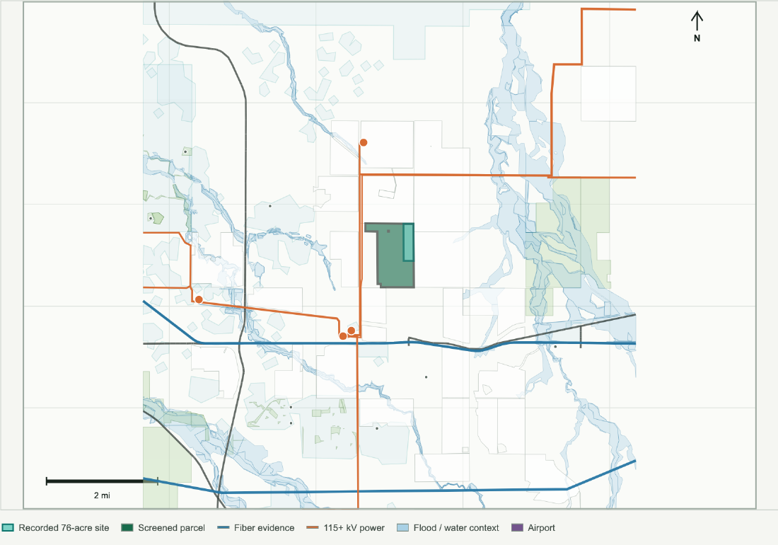
Aurora municipal benchmark with a recorded 76-acre site inside a 493-acre screen. The county drafting direction does not change this site's governing process or prove availability.
- Broader screen acres
- 493 acres
- Fiber corridor distance
- 1.46 mi
- Transmission / substation
- 0.75 mi / 1.57 mi
- Water-system boundary
- 1.38 mi
Distance basis: Recorded 76-acre tract boundary; deed-derived, not surveyed. Buildable acreage, utility capacity and service commitments require project-specific verification.
Location context
- Recorded site: 76 acres inside the broader screen; deed-derived extent, not a survey
- Approximately 493 acres in the public parcel screen
- Public zoning/context code: AD
- Community screen: moderate
Crosswalk the recorded site to current tax parcels, survey/title exceptions, and legal access before utility or provider verification.
Research profile 02
Aurora East B
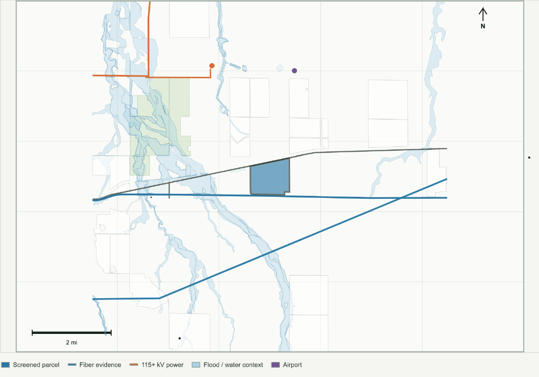
Aurora municipal industrial comparison with close fiber context and a weaker substation lead. Current city rules, planned homes and project eligibility require confirmation.
- Public screen acres
- 512 acres
- Fiber corridor distance
- 0.04 mi
- Transmission / substation
- 2.46 mi / 2.73 mi
- Water-system boundary
- 0.13 mi
Distance basis: Original public parcel screen. Buildable acreage, utility capacity and service commitments require project-specific verification.
Location context
- Approximately 512 acres in the public parcel screen
- Public zoning/context code: I-2
- Community screen: high
Determine whether the power path is relevant enough to justify utility confirmation.
Research profile 03
Quincy Industrial East
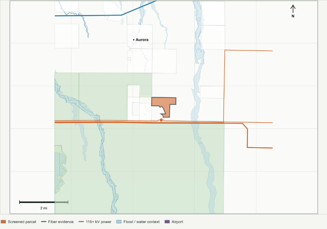
A 288-acre unincorporated Arapahoe parcel screen with I-2 zoning and close mapped power. Fiber is a material gap. No current standalone data-center approval pathway.
- Public screen acres
- 288 acres
- Fiber corridor distance
- 6.01 mi
- Transmission / substation
- 0.09 mi / 0.14 mi
- Water-system boundary
- 0.10 mi
Distance basis: Original public parcel screen. Buildable acreage, utility capacity and service commitments require project-specific verification.
Location context
- County GIS checked Oct 24: I-2; unincorporated Arapahoe
- Drafting direction reported Oct 19; no ordinance adopted
- Residential separation and availability unverified
Confirm draft district eligibility, residential separation and utility delivery. Establish owner interest and a credible fiber route.
Research profile 04
Quincy Industrial West
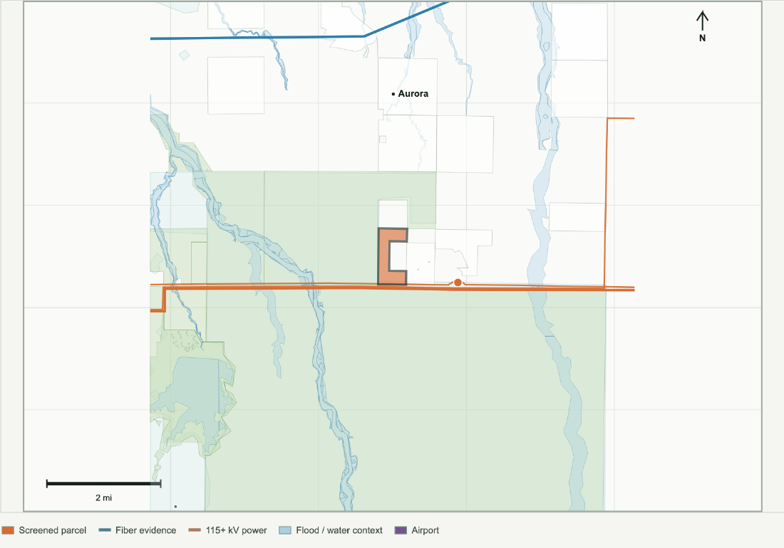
A 212-acre screen with approximately 92.9% I-2 PUD zoning and 7.1% F zoning. PUD terms, usable area and the future county pathway remain unresolved.
- Public screen acres
- 212 acres
- Fiber corridor distance
- 6.01 mi
- Transmission / substation
- 0.00 mi / 0.91 mi
- Water-system boundary
- 0.00 mi
Distance basis: Original public parcel screen. Buildable acreage, utility capacity and service commitments require project-specific verification.
Location context
- County GIS: 92.9% I-2 PUD; 7.1% F; PUD terms unverified
- Drafting direction reported Oct 19; no ordinance adopted
- Residential separation and availability unverified
Review the PUD documents and F district limits, then test residential separation, service delivery and draft-code eligibility.
Research profile 05
Strasburg Industrial Area
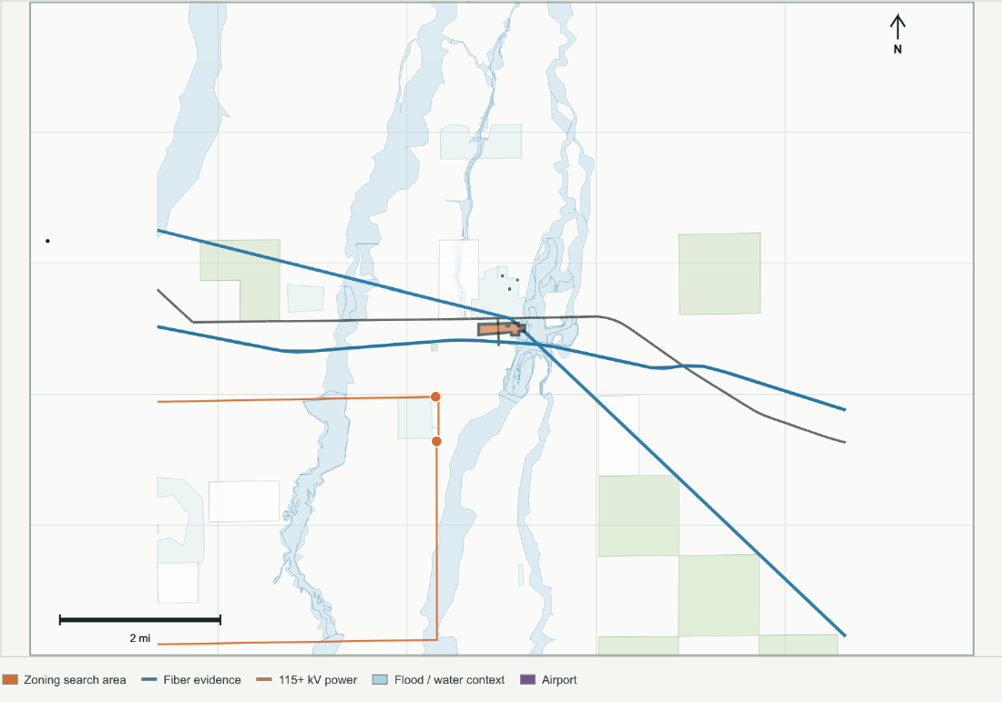
A roughly 43-acre I-1 zoning footprint near the I-70 corridor. This is an industrial search area, potentially covering multiple properties and existing uses; site availability is unverified.
- Zoning footprint acres
- 43 acres
- Fiber corridor distance
- 0.00 mi
- Transmission / substation
- 0.49 mi / 0.94 mi
- Water-system boundary
- 0.00 mi
Distance basis: October 24 zoning-area boundary to retained infrastructure layers. Buildable acreage, utility capacity and service commitments require project-specific verification.
Location context
- About 43 acres of I-1 zoning; search area, not one offered parcel
- Drafting direction reported Oct 19; no ordinance adopted
- Residential separation and availability unverified
Identify available properties, existing uses and nearby homes; reconcile Strasburg 2050 with future district eligibility and utility delivery.
Evidence needed before advancing a site
Confirm the governing code and development documents, measure existing and planned residential separation, establish owner willingness, and obtain project-specific utility responses. Development feasibility remains unverified for all five profiles.
Power delivery
Define phased load, delivery dates, studies, upgrade costs and the utility's requirements.
Fiber connectivity
Confirm carrier routes, splice access, physical diversity, construction scope and commercial terms.
Water and wastewater
Match cooling, fire protection and wastewater assumptions to provider eligibility and capacity.
Updated policy and zoning: October 19 county staff report; county unincorporated zoning and jurisdiction layers, checked October 24; Strasburg 2050 adoption. Zoning intersections are approximate screening measurements, subject to survey and county confirmation.
Retained infrastructure: County parcel geometry, HIFLD transmission and substations, CDOT highways and fiber evidence, EPA water-system boundaries, FEMA flood hazards, PAD-US protected lands, and school and airport context. Infrastructure data retain their original screening snapshots. Aurora East A uses a deed-derived 76-acre tract for distances within its broader 493-acre screen. Strasburg uses its zoning footprint. A displayed 0.00 miles means mapped overlap or rounding. Connection and service rights require provider confirmation.